


Bought with Mooers Realty
$55,750
For more information regarding the value of a property, please contact us for a free consultation.
M2L24B McIntyre RD Woodland, ME 04736
59 Acres Lot
Key Details
Sold Price $55,750
Property Type Land
Listing Status Sold
MLS Listing ID 1611158
Sold Date 01/23/25
HOA Y/N No
Annual Tax Amount $853
Tax Year 2024
Lot Size 59.000 Acres
Acres 59.0
Source Maine Listings
Property Description
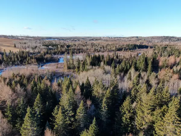
Welcome to ''Trail Riders Escape,'' a 59± acre property located on McIntyre Road in Woodland, Maine. Situated in Aroostook County, also known as ''The County'' by locals, this waterfront property offers a rare combination of solitude, recreation, and opportunity.
LOCATION
Aroostook County, Maine's largest and most northern county, spans over 6,800 square miles, making it larger than Connecticut and Rhode Island combined, yet with a population density of less than 10 people per square mile. Woodland, with a population of 1,217, is an ideal location for those seeking privacy and outdoor adventure.
The property is just six miles from Caribou, offering convenient access to shopping, a hospital, and other services. For additional amenities, Presque Isle is 18 miles away and provides access to the University of Maine at Presque Isle, a commercial airport, restaurants, and a large medical center. The Canadian border town of Fort Kent is only 42 miles away, and both Boston and Montreal are within a 6.5-hour drive.
LAND
This property includes 59± acres of forested land with 2,800± feet of frontage on South Branch Caribou Stream. This slow moving stream is a nice place to paddle a canoe or kayak. Moose sightings along this stream are common.
The soils, composed of about 40% Conant silt and Caribou gravelly loams according to NRCS mapping, are suitable for timber production, farming, grazing and wildlife uses.
With elevations ranging from 540 to 590 feet above sea level, the property provides gentle topography and stunning natural surroundings.
The town-maintained road offers convenient year-round access, and grid power electricity is nearby.
POINTS OF INTEREST
Recreational opportunities abound here. The property is located just 500 feet from ITS 83, part of northern Maine's extensive 1,300-mile interconnected trail system that connects to other snowmobile and ATV trails across the state.
Location
State ME
County Aroostook
Zoning Shoreland
Body of Water South Branch Caribou Stream
Exterior
Parking Features No Driveway, None
Waterfront Description Stream
View Y/N Yes
View Scenic
Building
Lot Description Rolling Slope, Wooded, Rural
Sewer Septic Needed
Water Well Needed on Site
Others
Restrictions Unknown
Read Less
Want to know what your home might be worth? Contact us for a FREE valuation!

Our team is ready to help you sell your home for the highest possible price ASAP